Kardi Teknomo
Kardi Teknomo Kardi Teknomo Kardi Teknomo
   
 
Research
Publications
Tutorials
Resume
Personal
Resources
Contact


GIS Tutorial:

What is GIS
GIS data model
Vector Data
Point
Line
Polygon
Vector Representation
Raster Data
TIN model
Scale of Map
Introduction to ArcGIS
Exploring ArcMap
Basic GIS technique
Extract part of the map
Query by Attribute
Create layer from selection
Convert Layer to Shape File
Create a New Map from Extracted Layers
Create Choropleth map
Showing only selected layers
Create Dot Density map
Change Symbol of Points
Buffer
Geoprocessing
Add Field and Calculate Value of Table
Statistic, Sort and Summary
GIS Resources

GeoProcessing Wizard:

Dissolve, Merge, Clip, Union , Intersect

By Kardi Teknomo, PhD.


<Content | Previous | Next >

Doing geoprocessing in ArcGIS is very simple because it contains wizard that you can do only by a few clicks. All you need to do is to use menu Tools > GeoProcessing Wizard . It has 5 tools Dissolve, Merge, Clip, Union , Intersect and I think the wizard is already self explanatory.

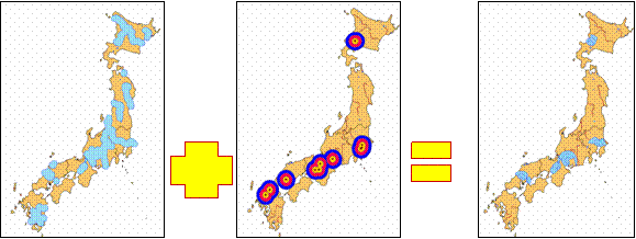
If you have done the practice of last tutorial about buffer, you will get river and city buffers. Now you can intersect the two polygon buffers to examine which cities in Japan has been influence by big rivers


<Content | Previous | Next >

This tutorial is copyrighted.

Preferable reference for this tutorial is

Teknomo, Kardi. Introduction to GIS. http:\\people.revoledu.com\kardi\ tutorial\GIS\


© 2006 Kardi Teknomo. All Rights Reserved.
Designed by CNV Media