Raster Data
One method to represent GIS data model is using raster or Image.
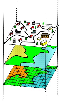
 The figure on the left shows a land use map of a neighborhood. In the top layer, we use symbols to represent the location of houses or factories or commercial centers. The black lines are the land use boundary. The middle layer shows the land use map and the bottom layer is the conversion from the land use map into raster model.
Raster model use grid or cell as unit to store data, similar to Image. Each cell has coordinate and corresponding attributes. For example, cell in the location (5, 7) may have associated attribute of land use, population density and crime rate.

Using raster model to store GIS data, we can use many image processing analysis that have been quite developed in the fields of computer science and computer vision, which is outside the field of geography and spatial analysis.
This tutorial is copyrighted .
Preferable reference for this tutorial is
Teknomo, Kardi (2015) Introduction to GIS. https:\\people.revoledu.com\kardi\ tutorial\GIS\
