Kardi Teknomo
Kardi Teknomo Kardi Teknomo Kardi Teknomo
   
 
Research
Publications
Tutorials
Resume
Personal
Resources
Contact


GIS Tutorial:

What is GIS
GIS data model
Vector Data
Point
Line
Polygon
Vector Representation
Raster Data
TIN model
Scale of Map
Introduction to ArcGIS
Exploring ArcMap
Basic GIS technique
Extract part of the map
Query by Attribute
Create layer from selection
Convert Layer to Shape File
Create a New Map from Extracted Layers
Create Choropleth map
Showing only selected layers
Create Dot Density map
Change Symbol of Points
Buffer
Geoprocessing
Add Field and Calculate Value of Table
Statistic, Sort and Summary
GIS Resources

Create Layer from Selection

By Kardi Teknomo, PhD.

<Content | Previous | Next >

Now you have a selection in ArcMap and you want to extract only this selection as layer map.

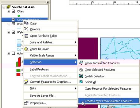
  1. In the left panel, that is table of content of the layers; do right click on layer Administrative Boundary . A pop up menu will be shown.
  2. Click on the pop up menu: Selection > Create layer from selected features . A new layer is created
  3. Rename this new layer by clicking on its name and wait for a second then type the new name
  4. Do right click again on the name of the new layer, on the pop up menu click Save it as Layer

Do above procedures for other layers such as Cities , Rivers and Water Features

<Content | Previous | Next >


This tutorial is copyrighted.

Preferable reference for this tutorial is

Teknomo, Kardi. Introduction to GIS. http:\\people.revoledu.com\kardi\ tutorial\GIS\


© 2006 Kardi Teknomo. All Rights Reserved.
Designed by CNV Media