Data Model
In previous section, I simplified GIS as maps plus database. Database is represented by tables. Table consist of rows represent the data and columns characterize the attributes of the data. On the other hand, Map may be represented by several GIS data model such as vector, image (raster) and triangles. Knowing the data model of GIS is important because it gives you idea on how the computer stores the data and how the data is analyzed. Depending on this GIS data model and representation, the way to perform your analysis and the result you obtain may be different. In this section, you will learn this GIS data model.
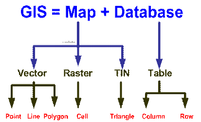
see more detail explanation in the following section:
This tutorial is copyrighted .
Preferable reference for this tutorial is
Teknomo, Kardi (2015) Introduction to GIS. https:\\people.revoledu.com\kardi\ tutorial\GIS\